Wireless Positioning and Channel Charting with NVIDIA Aerial Omniverse Digital Twin
Our ongoing and upcoming research at the Integrated Information Processing (IIP) Group is incorporating synthetic wireless channel data obtained with the external page NVIDIA Aerial Omniverse Digital Twin into our machine learning (ML) research projects. Aerial Omniverse Digital Twin is an operator-scale digital twin for system-level simulation. Built on NVIDIA Omniverse, Aerial Omniverse Digital Twin scales to hundreds of base stations (BSTs) and thousands of user equipments (UEs). It is implemented using the full 5G NR physical layer from NVIDIA combined with RTX-accelerated ray-traced channels. It can be used for the production of spatially coherent channel model data sets for training in Sionna, PyTorch, or other ML frameworks. Aerial Omniverse Digital Twin can be used to produce ray-traced synthetic channel model data for training neural networks (NNs), which is the main focus of our research. This blog post summarizes our ongoing research activities centered on NVIDIA Aerial Omniverse Digital Twin.
Wireless Positioning with NVIDIA Aerial Omniverse Digital Twin
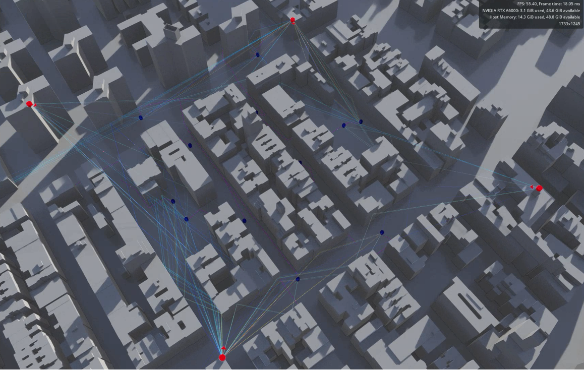
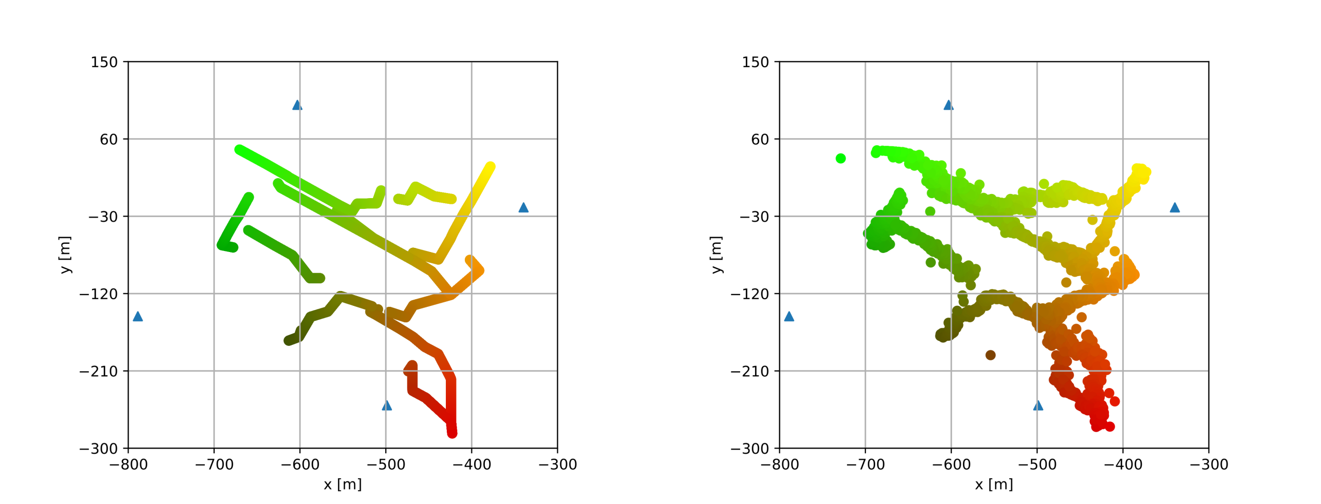
Our previous work focused on using NVIDIA Aerial Omniverse Digital Twin channel impulse response (CIR) data for supervised channel state information (CSI)-based UE positioning. Supervised CSI-based UE positioning consists of training an NN with a mean squared error (MSE) loss that compares the predicted UE positions to ground-truth labels, i.e., true UE positions. In contrast to prior research focusing on supervised UE positioning, the integration of NVIDIA Aerial Omniverse Digital Twin ray-traced channels presents a unique advantage: the ability to simulate complex and large scenarios with UE movements, allowing us to rapidly gather large and realistic CSI datasets. Figure 1 shows the NVIDIA Aerial Omniverse Digital Twin simulation geometry and Figure 2 shows the resulting estimated UE position map.
Wireless Channel Charting with NVIDIA Aerial Omniverse Digital Twin
Our next steps will focus on using NVIDIA Aerial Omniverse Digital Twin complex frequency response (CFR) channels for channel charting (CC). CC is an emerging self-supervised method that learns a map and transforms it from high-dimensional CSI space to a low-dimensional representation called the channel chart. The key property of a channel chart is that UEs that are nearby will be nearby in the channel chart [1]. Although this technique excels at preserving local geometry, it distorts global geometry, resulting in UE positions in arbitrary coordinates. To address this constraint, we have proposed CC in real-world coordinates [2]. This work leverages the fact that BST positions are known after their deployment and that strong received power at a certain BST coming from a certain UE indicates that the UE is in close vicinity to the BST. This technique enables one to perform approximate positioning but in a fully self-supervised manner. In addition, we have proposed a novel streaming CC architecture [3] that deals with the issue of storage limitations, as high-dimensional CSI is generated at extremely fast rates. This architecture maintains only a small set of representative CSI data, from which channel charts are learned.
Please visit the website for more details on another recent collaboration with NVIDIA, where we deployed a 5G virtual radio access network (vRAN) system built upon external page NVIDIA Aerial Research Cloud platform and the external page CC resources page for more details on recent research in CC.
References:
[1] C. Studer, S. Medjkouh, E. Gonultaş, T. Goldstein, and O. Tirkkonen, "Channel Charting: Locating Users Within the Radio Environment Using Channel State Information," in IEEE Access, vol. 6, pp. 47682-47698, 2018, doi: 10.1109/ACCESS.2018.2866979, external page arXiv.
[2] S. Taner, V. Palhares, and C. Studer, “Channel Charting in Real-World Coordinates, ” in Proc. of the IEEE Global Communications Conference (GLOBECOM), Dec. 2023, external page arXiv.
[3] S. Taner, M. Guillaud, O. Tirkkonen, and C. Studer, “Channel Charting for Streaming CSI Data, ” in Proc. of the Asilomar Conference on Signals, Systems, and Computers, Nov. 2023, external page arXiv.